
When we talk about Puno, the first thing that comes to mind is Lake Titicaca. However, this department has hidden corners that have a special magic. Today, we bring you a new place to visit on your trip to southern Peru: the Tinajani Canyon. Keep reading and discover this wonderful destination!
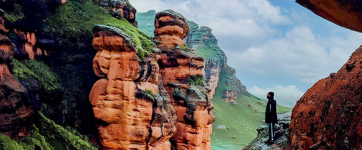
The Tinajani Canyon, also called the Devil's Canyon, is a spectacular place located about 15 kilometers from Ayaviri. Meeting of 3 canyons, the place is magical with huge rock formations over fifty meters and typical landscapes of the highlands.
The Tinajani Canyon has an area of 250 hectares and is located at 3953 meters above sea level. This is formed by three large ravines, Queñuacuyo, Pacobamba and Huarachani. With this, the natural landscape takes on unpredictable figures with very particular configurations. It is an ideal destination for those who like to practice adventure sports such as rock climbing, paragliding, hiking and horseback riding, among others.
Within its vast territory you can find huge stones that have been carved and molded thanks to the wind and the various meteorological circumstances. The different shapes of these stones can be interpreted in various ways by visitors. Among these can be found human figures, lizards, granite ghosts and winged sphinxes. These rocks can measure from 50 meters to more.
The reason why the Tinajani Canyon has such particular rock configurations is because millions of years ago the area was covered with water and there was a lot of volcanic activity. Thus, changes in temperature and wind phenomena gave way to the Tinajani Canyon being the natural wonder that it is today.
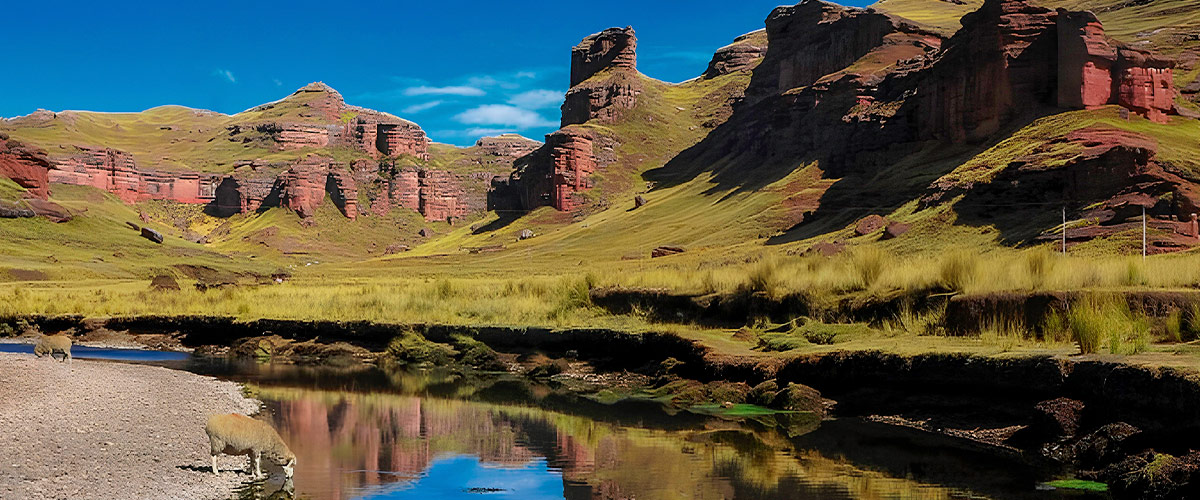
The Tinajani Canyon is a perfect place for those who love to explore impressive natural landscapes. In its more than 200 hectares you will find imposing and gigantic sandstone rock formations that give this space its characteristic reddish color.
These formations are accompanied by the Pacobamba, a river with calm crystal clear waters that runs through the ravines of the canyon. The landscape that you can see in this place will leave you speechless!
In addition to having an enviable natural wealth, it was also the territory of Quechua-speaking inhabitants of the Qaluyo culture. This population was settled in the valley of the Pacobamba River, which is very close to Tinajani. What can be seen of this culture are the tombs and chullpas that are still found within the territory of the Canyon.
Thanks to residents who still participate interacting with the Canyon, very popular traditions and festivities are maintained. Thus, in July the Music and Dance Festival is held at the foot of the Tinajani. This event brings together not only hundreds of dancers from all over the region, but also national and foreign visitors who come with the desire to see the culture of the highlands in action.
The Canyon is not only a beautiful natural setting, on the contrary, it is part of the oral tradition of the region. Thus, various legends about Tinajani have been inherited.
One of the most famous is the one that tells that the Inca Pachacutec was worried because the Collasuyo region was going through a drought, which meant that there was no food and that the inhabitants and animals were dying.
To counteract the drought, the Inca gathered the best diviners, who responded that the cause of this phenomenon came from the presence of a devil that had taken possession of the region. Given this, Pachacutec sends his army to make three stone jars in the Tinajani ravine so that the devil can purify himself in the cold waters and leave the region or remain prisoner in the waters.
The villagers say that in the rainy months you can hear the voice and the moan of the devil trapped in the jars. However, other residents say that it is on cold nights when the devil bathes in the waters.
The temperature of the Canyon ranges from 19°C to -2°C, so it is recommended that when you go to visit you wear warm clothes and also a light polo shirt. The ideal season, likewise, is between April and October. How to get to the Tinajani Canyon?
The Tinajani Canyon is located 12 kilometers southeast of Ayaviri, province of Melgar, in Puno.
To get to this natural area you have to go to Pucará, 2 hours from the city of Puno. From this point the route that goes to Cusco is crossed. Along the way you will be able to observe a desolate scene but full of ichu, the typical grass of the Andean highlands, which gives a yellowish hue to the view. Likewise, you will be able to observe many undulating rivers that are reminiscent of those found throughout the Peruvian Amazon. At times, you can also see cattle running or eating grass in their natural habitat. When the Cordillera de la Raya begins to appear in the Andes and you see snow-capped peaks like Chimboya, you will know that you are approaching the Ayaviri district. When you get there, it will only take you 10 minutes to the entrance of the Tinajani Canyon. You can do this tour with a mototaxi from Ayaviri.
The welcome to the Canyon will be given by a 93-meter-high rock, named among the residents as El Vigía. From there, you must undertake a walk that will leave you speechless.
The city of Puno is one of the most beautiful cities in the high Andean region of Peru. In the city you can highlight the Cathedral, which was built with stones from ancient ceremonial centers such as those of Tiahuanaco and Incas. Also, inside the Cathedral you can see various canvases from the Cusco and Italian schools.
On the other hand, it is essential to visit the main square, the church of San Juan and the Parque del Pino.
Lake Titicaca is the most visited site by domestic and foreign tourists who come to Puno. It is the highest navigable lake in the world, located at 3812 meters above sea level. In its immensity, it houses several floating islands where you can find and learn about various communities that to date preserve many of their traditions.
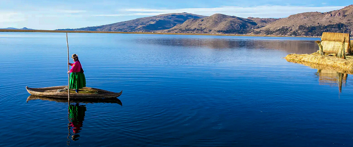
One of the many islands that Lake Titicaca houses is the Island of Uros and, without a doubt, it is the most important and visited. This island is made by Totora, a plant native to the region, which gives it the resistance to stay afloat. The Uros community is very receptive to tourists who visit the island, helping them learn about their customs.
To get to the Uros Island you can rent a boat ride from the port of Puno or take a tour from an agency in the city.
It is located 33 kilometers from the city of Puno in the direction of Cusco.
As its name says, in this place there are a large number of chullpas, which are constructions where the dead were buried in pre-Columbian cultures. Thus, the corpses were covered by plants and ointments were injected to keep them well preserved. They were also covered by looms, objects and foods that they liked when they were alive.
Many are the routes that take you to Machu Picchu, but none is like the Inca Trail Tours, the most famous pedestrian path in the Americas. After flying from the capital of Perú, Lima, you will arrive in Cusco to walk for four days along a path through forests and dense fog, millenary stone steps and discovering the ruins of ancient fortifications and Inca cities, and all the time enjoying majestic views.


