
Vestige of the Inca Trail that at one time served as a connection between the Archaeological Park of Choquequirao and the Citadel of Machupicchu, surrounded by abundant wild vegetation, where you can also observe birds, insects, crossing a transitional forest, a place that Currently it is used frequently by foreign visitors to be able to move first to the Llaqtapata from where you can see the back of the citadel of Machu Picchu with an impressive view of it, secondly it serves to move towards the hydroelectric power station of Machupicchu, from where foreign, national and / or local visitors can move to the town of Aguas Calientes. To access this road you can go from Santa Teresa Town to the sector of Lucmabamba (35 minutes by car) or descending from Choquequirao, Salkantay and take the aforementioned road that is signposted and maintained by the Ministry of Culture. During the trip you can see a variety of orchids and an abundant fauna of the area has a warm climate and an altitude of 4200m.a.s.l. and with an extension of approximately 60 kilometers.
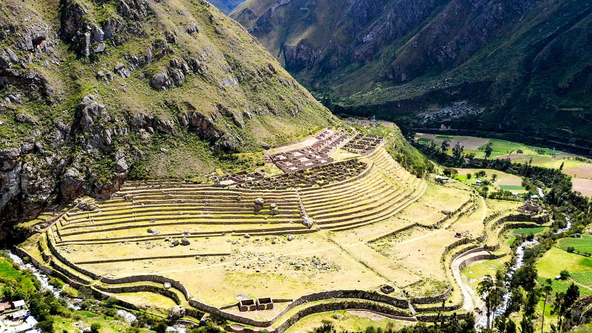
Llactapata - Llaqta = Town, Pata = High place, is an Inca town, located at 2,840 m. / 8,136 ft. at the confluence of the Cusichaca, Urubamba rivers in the mountain called Patallaqta, province of Urubamba, department of Cusco.
These are constructions with several well-defined sectors, enclosures, platforms, squares, canals, etc. Highlight, especially the agricultural terraces and their drainage system. This archaeological site should not be confused with another place of the same name, located west of Machu Picchu, which can be visited on the famous Salkantay Trek, which was a ceremonial center.
Llactapata of the Inca Trail was an eminently agricultural town, it was probably the place where the products of the Valley were concentrated. It has constructions separated from the platforms that could be barns.
The Inca Trail shows rugged geographies with ascents and descents on the side of precipices. The mountains reach great heights with uneven stretches. In the jungle areas you will see the variety of tones of green tropical forests.
Day 1: Cusco - Wayllabamba (13 kilometers)
The Inca Trail begins at kilometer 82 of the railway that leads to Machu Picchu (2 hours and 30 minutes by bus from the city of Cusco). Then the ascent to the valley of Cusichaca will begin. The visitor will visit the ruins of Llactapata (2,840 masl) until reaching the town of Huayllabamba (3,057 masl).
Day 2: Wayllabamba - Pacaymayo (11 kilometers)
The second day is the most difficult due to the physical demand. The tourist will ascend to the Warmiwañuska ('Passage of the dead woman'). This is the highest point of the route (4,215 m.a.s.l). From this point it is possible to see the archaeological site of Runkurakay (3,760 m.a.s.l).
Day 3: Pacaymayo - Wiñay Huayna (16 kilometers)
On the third day, the descent will be vertiginous to the valley of the Pacaymayo river. The section goes down a stepped slope of almost 1, 600 meters to the site of Sayaqmarca (3,625 m.a.s.l). Here the view is extraordinary.
Day 4: Wiñay Huayna - Machu Picchu (3 kilometers)
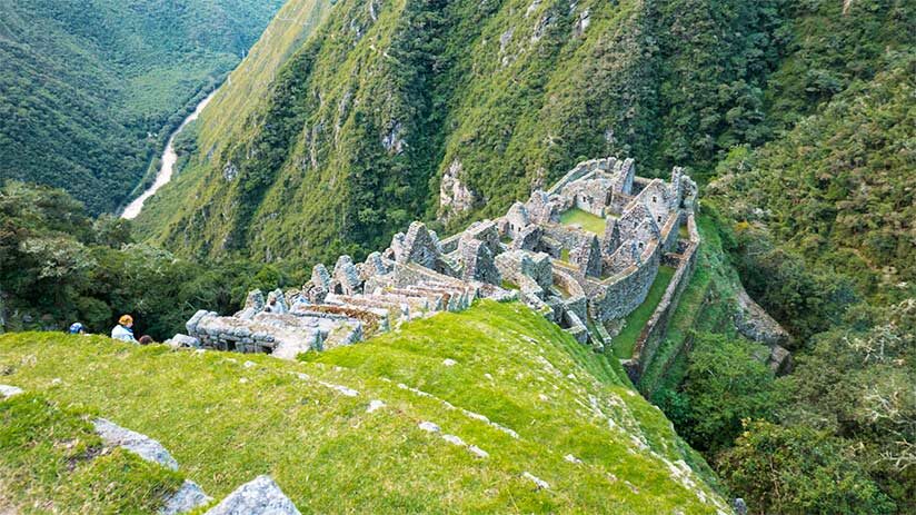
The last day hides some of the best Inca exhibitions: Phuyupatamarka, Wiñaywayna. When leaving these ruins, a gradual descent will be undertaken that will become more complicated in the end. Finally, you will arrive at the Intipunku or Sun Gate. From there you will walk for another 30 minutes to the Lost City of the Incas, Machu Picchu.
Particularity of the picturesque road Llaqtapata - Hidroelectrica:
Inca Trail, the only place where you can see the back of the citadel of Machu Picchu.
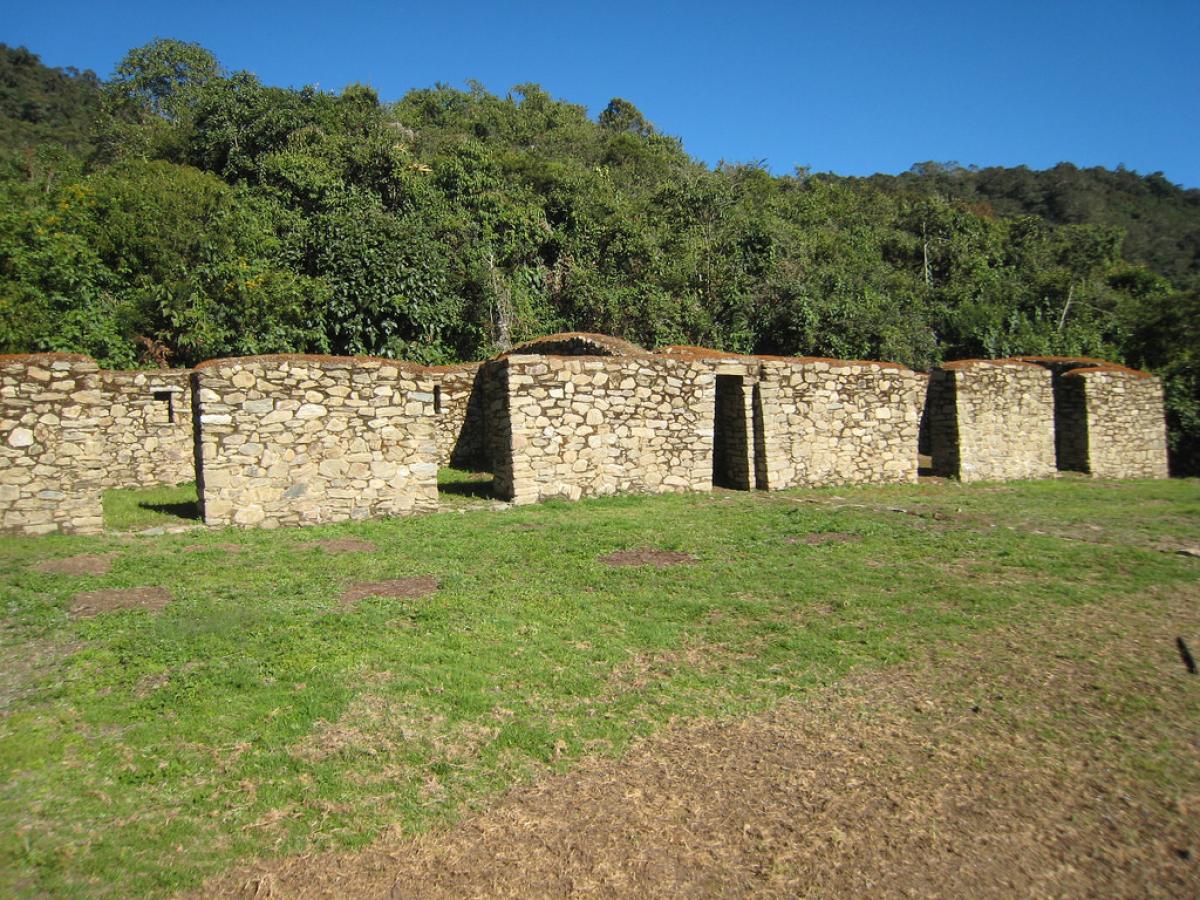
It is in a good state of conservation, by intervention of the Decentralized Directorate of Culture Cusco (former Regional Directorate Of Culture).
Due to the high demand for tickets, you must get entry tickets to the Inca Trail a long time in advance (6 months). The purchase is made only through the Internet through the website of an authorized tourism agency. In total 500 people enter the trails of the Inca Trail every day. Of them, only 200 are tourists. The rest is support personnel such as cooks, porters, guides. The ticket to enter the Inca Trail includes the support staff.
Did not find availability to do the Inca Trail? The only way to enter the Wonder of the World is by train through the Sacred Valley of the Incas or through the alternative route from Santa María to Machu Picchu that maybe is the cheaper alternative and sometimes the best for those natural lovers.Also you can experiment the adventure of Salkantay trek to Machu Picchu, the most famous alternative trek to Machu Picchu. Entrance tickets to Machu Picchu must also be reserved in advance.
From May to September (dry season) is the ideal time to travel the Inca Trail to Machu Picchu. These months are usually good for the crossing due to the low frequency of rains. In the months of November to March the summer (rainy season) occurs. This time is usually very rainy, which makes walking and access difficult. Even, it will not be able to cross the Inca Trail in February due to the precipitations and works of maintenance.


